
landscape and public realm design of the Lasarte gravel pit and its surroundings, in collaboration with Lucía Bárcena, landscape architect
location: Vitoria-Gasteiz, Basque Country, Spain
year: 2013
Our proposal of public realm and landscape for the southern limits of Vitoria-Gasteiz is based on the objectives and strategies proposed by the preliminary version of the Special Plan for the Protection and Conservation of Vitoria southern limits, drawn up by Lucía Bárcena Rebolledo, landscape architect, Adrián Díez Angulo, geographer, Beatriz López de Suso Marina, architect, Eduardo Sola Beperet, architect, Miguel Ángel Venegas Pérez, architect, e Idurre Zugazagasti Aja, environmentalist, as a workshop project for the UPV-EHU Master of Landscape Architecture and Planning.
The aim of the Plan is to highlight the agricultural, productive, environmental and landscape values of the land classified as not for building in the southern area of Vitoria-Gasteiz, around the small villages (ELM) of Arechavaleta, Berrosteguieta, Gardelegui and Lasarte. Although this area has kept for decades its agricultural and rural identity, nowadays it is being transformed through the urban development of the old agricultural plots. There are more specific goals to this Plan, such as defining a permeable and full of life urban limit which can work as a transitional area between the city and its environment, giving a singular identity to the ELMs or recovering the abandoned rural land to be used as public areas. In order to accomplish these objectives, the Plan proposes strategies and actions related to the permeability, connectivity, identity and functionality of the area, aiming to create a clearly defined border which can blend in with the city. For example, a network of new cycle and pedestrian paths that will make this area more accesible, highlighting the cultural and agricultural heritage of the small villages and the Montes de Vitoria mountains which close the area to the south. On account of this, our proposal is focused on the revitalisation of the South of Vitoria from its rural identity and the agricultural and forest potential values of the area to provide new functionalities to the territory and to be part of the Green Belt which circles Vitoria-Gasteiz.
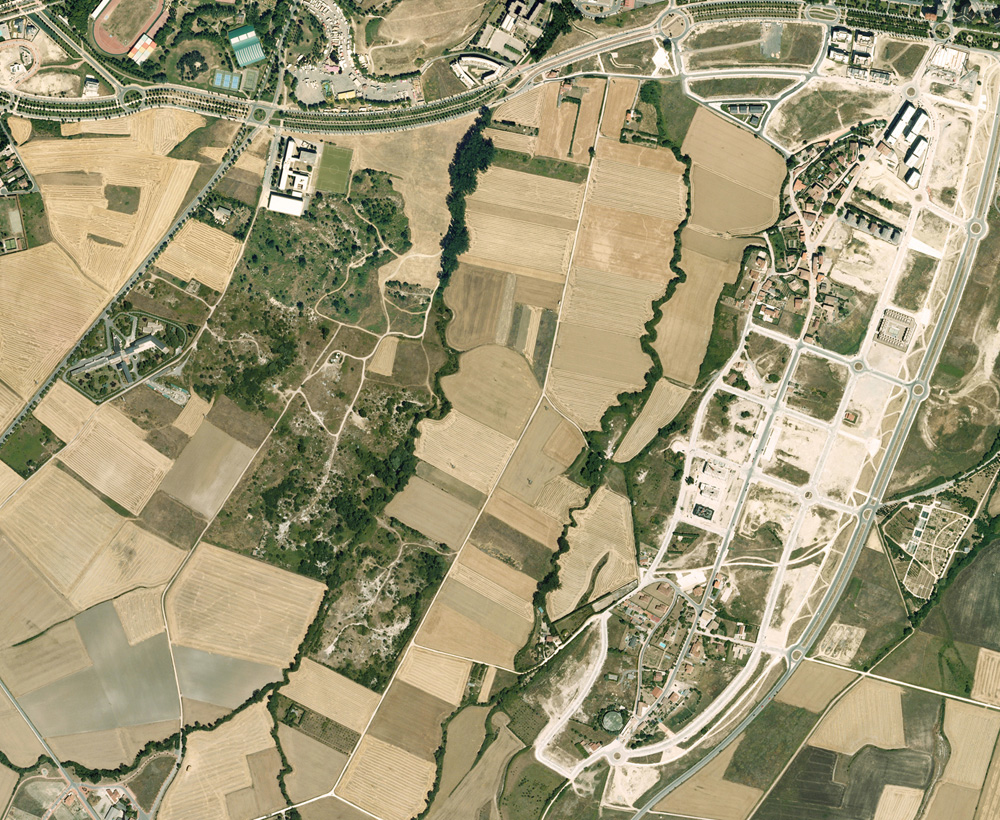
The project area shows an obvious contrast between three different and well-defined areas: the more urban and completely incorporated into Vitoria-Gasteiz northern plots, the agricultural but in a process of change middle areas, and the forest covering the slopes of Montes de Vitoria along the southern limits. The highest environmental impact is found on the north-eastern limit, where a huge urban development is taking place between Arechavaleta and Gardelegui as a new wide neighbourhood. Besides, this new development has a strong visual impact because of its location on a hill which dominates over the territory. Lasarte and Berrosteguieta have also had their own urban growths, so it is obvious that it is taking place a certain loss of the agricultural land values which transforms the small villages of the south of Vitoria into urban areas of their own.
The gravel pit of Lasarte and the landfill site of Gardelegui are two other land-use elements with a high environmental impact. Although the landfill is placed outside the project site, there is a great risk of groundwater pollution by leaching since the Zapardiel river runs along it. The gravel pit -located next to the Batán river and surrounded by cereal and farming plots- is still used today as an illegal dump for all kind of waste: it is an area where the quaternary aquifer which provides Vitoria-Gasteiz with water has emerged due to the extractive activity kept for so long, and where the waste accumulation highly risks leaching and pollution by nitrates and metals. Therefore, cleaning the site and depolluting the soils should be the first goals to achieve. In fact, the landfill site of Gardelegui needs a management plan which includes the requirements for a suitable and progressive closedown.
The riverside forests of the Batán and Zapardiel rivers work as ecological corridors between the Montes de Vitoria mountains and the inner city while crossing the project site from the south to the north. What’s more, as part of the Green Belt of Vitoria-Gasteiz, the agricultural southern area of the city are merged to the Forest of Armentia -to the west- and the Park of Olárizu -to the east- by the pedestrian and cycle paths which run through the cereal fields and the vegetable gardens. Moreover, that helps to join the inhabitants with the cultural and agricultural values of the natural environment which wraps both the city and the small rural villages.
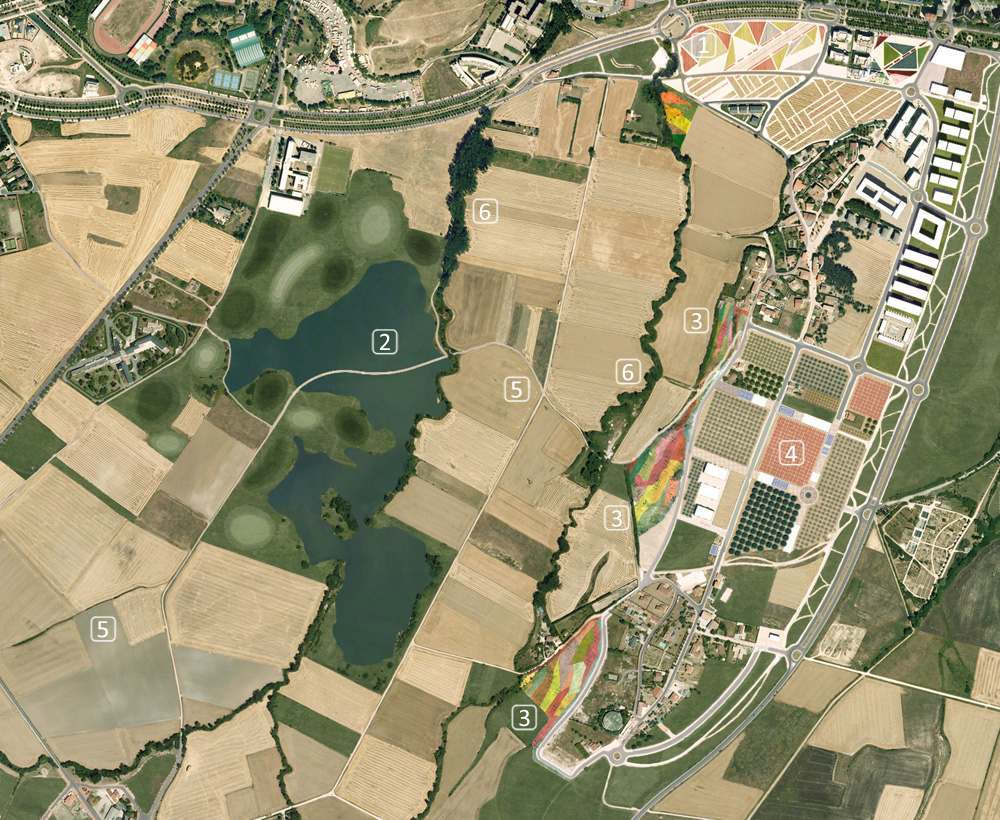
Our landscape project for the southern area of Vitoria-Gateiz is based on all these existing factors to create a land-use strategy which harmonizes the protection of the natural environment and the mitigation of the environmental impacts, with the agricultural productive uses, the enjoyment of the public realm and an urban development more adapted to the small rural villages character. To keep the ecological and formal values and the visual continuity between the Montes de Vitoria and the city through the Green Belt of Vitoria-Gasteiz, we use six basic tools:
1. A new urban border: the limits between city and farming plots are not yet defined, but roughly drawn as a clearly urban street besides the rural plots. Our design proposes new green areas with pedestrian and cycle paths along this street: in short, a wider street built with local materials which offers new public areas and parks as visual and functional filters between the city and the agricultural land.
Where the urban fabric is denser, or where there are not green areas or a public space which could easily be incorporated to the street -such as in Arechavaleta, on the east-, we propose to reuse some unbuilt residential plots as public areas. Designed as gardens with triangular-shaped flower beds, they are covered by small bushes and ornamental aromatic plants with blue, red, yellow and white small flowers and arranged around other public squares and diagonal pedestrian paths to connect the urban fabric and the rural land. The path along the Batán river runs elevated when crossing at the north street to give priority to the pedestrian flow and to strengthen the continuity of the Batán ecological corridor. To the west, Mendizabala hill, Mendizorroza’s sport area and the buildings of the University of the Basque Country work as filters between the urban fabric and the agricultural plots.
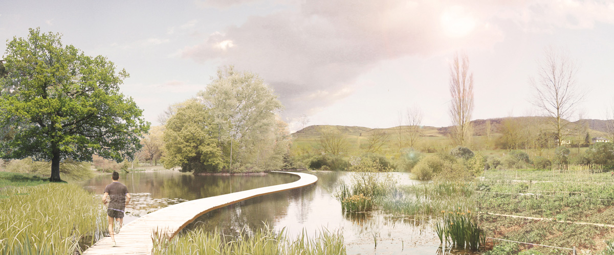
2. A wetland against flooding: the floods of the Batán and Zapardiel rivers can be controlled by delimiting an area to stabilize the instant water flow and reduce the saturation of the sewerage system in which those rivers run. We propose the old gravel pit of Lasarte as the flooding area: it would be the key to start the environmental restoration of the contaminated soils, which are affecting both the Batán river and the quaternary aquifer of Vitoria that runs under the city.
In addition, we intend to give some landscape values and a compatible public use with the water management by creating leisure areas with different degrees of privacy and oriented to the landscape. These areas of flood-resistant grass with a strong power of regeneration would cover an artificial topography of small hills, ponds and dips made of the decontaminated soils obtained from the own site. We also propose to keep a certain volume of water in the pond that would help the site to be noticed as a pleasant area without risking the flood management: a wooden footbridge running over the deepest area of the pond gives aesthetic and sensory values related to the sheet of water and also relinks the paths that cross the site from the south to the north and from the east to the west.
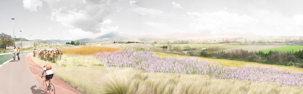
3. The slope of Arechavaleta-Gardelegui: although the hill under Arechavaleta-Gardelegui is not only visible from the nearest territory and holds strong identity and perceptible values, it is however affected by an uncontrolled dumping activity over its east slope. What’s more, it is being transformed into a new housing development based on urban models which we think are far from what a rural area should be.
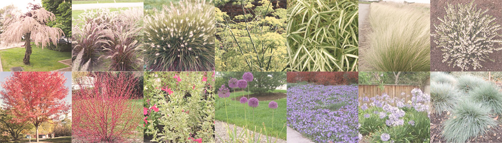
Speaking about the vegetation chosen to be planted on the slope, we have selected different varieties and species according to their flowering, sheet colours, fragrance and the silhouette of their branching for keeping the ornamental interest on every season. They have been chosen to characterize and connect the different areas. The trees are understood as marks of the public realm. This way, these areas could be easily identified from a faraway point of view. The strategy to cover the slope is focused on the contrast of textures and colours between the plants of delicate flowers and tight and long sheets, and the rough plants of wider and shinier sheets. In addition to the textures and colours, the combination of curved stem and pendulous plants gives an extra appeal to the place. To this end, the big irregular areas on the slope are designed to be covered by a specific kind of plant but without any of them taking a greater role. That is, this mixed plantation is used to focus on both the singular interest of each plant and the shapes drawn by the group of plants when growing together.
4. The tree nursery: over the hill of Arechavaleta-Gardelegui a new urban area is growing to the east, modifying the character of the small towns and their relationship to the territory. In order to contain this urban growth, the plots for building are resettled to the north, around Arechavaleta -the most transformed and closest rural village to Vitoria-Gasteiz-, to break the urban continuity that the actual planning had proposed. To create a valuable city border and keep the functional and ecological continuity towards Olárizu park, we propose to recycle the unused streets of this new urban area to support sport facilities (paddle tennis, basketball, etc), greenhouses and other agricultural buildings. The inner plots of these streets would be transformed into an open and public tree nursery for growing forest and ornamental trees to be used in the city parks. The nursery also works as a meeting-point for the inhabitants and as a little market for selling local food, fruits and vegetables or exchanging products, techniques and knowledge.
5. The agricultural pattern: the agricultural pattern from Lasarte to the southern border of Vitoria-Gasteiz has high landscaping and productive values at risk due to the abandonment of the agricultural activity and the outsourcing of the rural villages around Vitoria-Gasteiz. To keep the agricultural pattern and raise awareness of their values we propose to create a farming park whose character would make possible to harmonize traditional productive uses with public ludic uses in order to enable synergies, spread knowledge and techniques, and highlight the agricultural landscape to the society.
6. The Batán and Zapardiel rivers: Batán and Zapardiel have a great potential as ecological corridors between the Montes de Vitoria and the city, but they could also articulate the routes in this area by designing two new pedestrian paths along the left riverside of each river. Moreover, they would also be used to widen-up, improve and strengthen the vegetation of the riverside. Thus, these two new paths are designed along a riparian forest that casts shadows over the river area and minimizes the sun exposure to make the walk even more pleasant. To the north, these new paths link the site with the city centre.
Materialization: the proposed actions are part of the global strategy to enhance the southern area of Vitoria-Gasteiz and promote a real regeneration of the site which has positive effects on both the productive use of the territory and its landscape. For its formalization, we propose to integrate a design with simple materials and landscape strategies into the rural environment where the project takes place. The paths will be repaired, stabilized and redefined with recycled compacted aggregates to make the pedestrian and cycle uses compatible with the agricultural machinery. We have avoided suggesting roads or urban constructive solutions, or unnecessary earth-moving works. The main idea is to develop a project which blends in with the environment. Accordingly, the materialization of the project is based on recycling the construction elements of the site and the placement of deciduous trees and bush vegetation with an extensive range of chromatic variety in the public realm and on the visually exposed areas.